Saturday, July 30, 2011

691. Going my way?


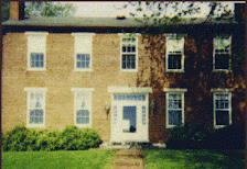
This morning's drive gave me a new perspective on the old Louisville Male High School building on the corner once affectionately known as "Brook and Breck." As I was driving southbound on Brook Street, the majestic brick building, which dates from 1915 and is one of Louisville's most beautiful buildings, took on new beauty. This was the first time I had approached it from this direction, which was from the north, the perspective shown in this picture.

I continued my trek southward on Brook to Hill Street, where I turned right for a block, and turned right again, this time headed northbound on First Street. First Street originally ended a half block north of Hill at what is now Hill Bend Place. I continued north taking in the southern exposures of many homes, especially those on the east side of the street, for the first time. The smaller craftsman types homes which occupy Ouerbacher Court looked particualrly different from this angle. I continued northward past the home of my friend Ken Herndon, which sits at the northwest corner of 1st Street and Ormsby Avenue.

This persepctive on Ken's house was not new. We were walking the area back in 2004 when he was looking for a new house and first caught glimpse of this one while looking at another at 1313 S. 1st, a few hundred feet south of there. But, again, we were walking. This time I was driving.

I continued northward on 1st until one is forced to turn either left or right onto West or East College Street, respectively, as the oncoming traffic is literally that, oncoming and all one way headed your way.

Several years ago, the late George Unseld, Louisville's 6th District Councilman for many years, began talk of making First and Brook streets two-way thoroughfares. For at least the last sixty years, they've been one-directional - First Street southward and Brook Street northward. Especially south of Kentucky Street, both streets are heavily residential, occupying the eastern flank of Louisville's victorian masterpiece of a neighborhood, Old Louisville.


The plan was to make the streets two-way from somewhere south of Broadway, where both have intersecting ramps with I-65, to Hill Street, generally accepted as the southern boundary of residential Old Louisville. South of Hill Street, Louisville's large educational campus begins to intermingle with the residences. Both the old and new Gavin Cochran Elementary School buildings are in the area, as well as Samuel V. Noe Middle School, and duPont Manual High School, all joined by the ever-expanding University of Louisville. But, I digress.

Councilman Unseld's proposal was met with both support and pushback. The residents wanted it; the city pushed back with a series of encumbrances seemingly designed to keep the Metro Council from ever changing any street from one-way to two, something the previous mayoral administration could and did do (perhaps illegally) on Main Street between 3rd and 4th with an Executive Order. A number of "percentages of residents' signatures" were suddenly needed to accomplish the plan. Unstated was the answer to the question will homeowners' signatures suffice or does it have to be the residents, even if they are renters, as there are a number of apartments and condos scattered in the several two, three, and four story homes in the neighborhood. And how do you count vacant residences and businesses into the equation? Every time a question was answered, either the percentages changed or a new question was asked.

The truth is the pattern of one-way streets in Louisville is governed by a vote of the Metro Council, successor to the old Board of Aldermen. It is a part of the traffic code, which itself is a part of the Louisville Metro Code of Ordinances. Nowhere in that code were any of these percentages mentioned. To some, including me, it seemed that a majority vote of the Council should have sufficed to change the traffic pattern. As one to-remain-nameless assistant county attorney often says (about any matter), any group of 14 votes of the 26 member council can change the local code. To be honest, I did not support the change; but also, to be honest, it was none of my business. I did not live in the affected area, although I did at one time.

Councilman Unseld did not live to see the street pattern changed. Upon his death last year, he was succeeded by an interim councilman, Dr. Deonte Hollowell, who was succeeded last November by the newly elected David James. Both Dr. Hollowell and Mr. James continued Mr. Unseld's efforts at changing the pattern.

During the last several weeks, driving in the area meant noticing the new two-facing stoplights and a number of new directional and no-turn signs. Early this morning, a double-yellow line was striped down the middle of both streets, effectively dividing them into two-way thoroughfares, thus completing the work began by the late Councilman Unseld several years ago.


I might note that when Mr. Unseld began this plan, no busses travelled along Brook Street, thus there was no need for any wide-berth swings which the busses need on some corners. The two most notable of these corners are 4th and Broadway, where southbound 4th Street busses swing widely into northbound 4th Street, and 3rd and Woodlawn, where northbound 4th Street busses swing widely into southbound 3rd Street. In the interim, the northbound Preston/18th Street line has been moved in this area from Preston/I-65/Jackson to Preston/Hill/Brook/Burnett/Preston/Jackson, passing along the new route, I might add, the eating establishment, Juanita's Burger Boy, of my friend Dan Borsch. Again, I digress.

The newly striped lines at Brook and Hill will, no doubt, have to be restriped to accomodate these northbound busses, as the current striping doesn't, something I experienced this morning when one of the busses attempted the turn with me in an up-close-and-personal perspective - perhaps too close.

So, if you are in the area, watch out for the new double yellow lines - and that TARC turning onto Brook from Hill. That bus is bigger than your car.

Happy Trails.

Tuesday, July 26, 2011

Disappearing Places


My friend Christa Robinson, who works for Congressman Yarmuth, has listed on her Facebook page that she is a resident of West Louisville, Kentucky. I happen to know that while she does live in west Louisville, she doesn't technically live in West Louisville, which is an entirely different place. I may or may not have rudely pointed this out to her - probably not because had I been rude to her, I am certain she would have responded in like manner, and that hasn't happened.

West Louisville, Kentucky is a place in Daviess County, a little burg along KY56 at its interesection with the Calhoun Road, numbered as KY815. I mentioned KY815 and West Louisville in a blog entry on August 27, 2010. Other than the Diamond Lakes Club and Whitaker's Gun Shop, there is very little in West Louisville other than a post office.

If you are old enough, you might remember when Shively was called Saint Helen's, named for the Catholic Church which itself has been recently renamed. But you'd have to be real old. One of the reasons Saint Helen's in Jefferson County became Shively was because of another town, Saint Helen's, in Lee County, a few miles east of Beattyville. That Saint Helen's, which I mentioned in a blog entry on Febraury 14, 2007, isn't as big as West Louisville. The only thing I remember on a drive through that area was a burnt out church, and, as usual, a post office. Alongside of the Middle Fork of the Kentucky River, you really couldn't even call it the proverbial "wide place in the road."


In another 2007 posting, this one on July 27, I copied the obituary of Mr. States Rights Aycock, II, dead at the age of 73, of Wickliffe, in far western Kentucky. One of Mr. Aycock's relatives hailed from the town of Columbus, Kentucky, which is in even-farther west Kentucky, a small town best known for its state park, the Columbus-Belmont State Park, which marks a Civil War battle best known as one of the places General Ulysses Grant first made a name for himself to people who mattered like President Abraham Lincoln. At that point in General Grant's career, several bureaucrats were on the ladder between him and the Commander-In-Chief. By the end of the war, Grant would like climb that ladder to the top rung. Columbus is located in northwestern Hickman County at the intersection of KY58, KY80, and KY123. It is spread out on several mostly unpopulated lanes including one called Hoover Parkway. As the map at left indicates, the town plan is quite extensive. The actual town that remains is very, very small. There is a the aforementioned state park, a fire house, and the post office.

In an entry on August 23, 2007, while writing about a Special Session of the Kentucky General Assembly, to be called by then-governor Ernie Fletcher, I included the lyrics of John Prine's famous song about the Paradise Coal Mine, Muhlenberg County, and the Green River. In one of those verses is mentioned the dam on the Green at the town of Rochester, which is in western Butler County. Of all these places I mentioned thus far, Rochester really is a town, with a few actual city blocks - maybe three. It is situated at the aforementioned dam on Green, at the mouth of Mud River along KY70, where Butler, Muhlenberg, and Ohio counties meet. KY70 to the west heads into Muhlenberg; the ferry across the Green follows KY369 into Ohio; and KY70 south (and east) leads past the town cemetery on the west side of the road up South Hill to Morgantown, the county seat. Aside from a few bait shops, the only other place of record is a post office.

In each of these places is a common denominator - the local post office. Over the years my travels have taken me past many post offices, large and small, decorative and plain, all of them having responsibility not only for delivery and pickup of the local mail, but also, importantly, for identity. Alas, all of these places above, and 127 others in Kentucky, and 3649 others across the Republic, are slated for possible closure.

Closing post offices can be divisive and traumatic. A few years ago there were rumors of the Valley Station Post Office in Jefferson County closing. It isn't on this list but three others in the area are - the Shelby Station, the Dr. Martin Luther King Branch, and the Air Mail facility at Standiford Field, the latter of which seems a little oxymoronic.

Victim to less mail and the internet, post offices are becoming questionable expenses in some people's minds. A few days ago, my dear friend Preston Bates and I had coffee at Sunergos on S. Preston Street, two blocks north of the Shelby Station Post Office. Preston offered that post offices should not have a monopoly on the delivery and pickup of mail - that postal service was one area of the government which should be parcelled out to private enterprise. While I disagreed with most of what Preston had to say, on this point he may have a point. More and more of our mail has been converted to email and social media outlets. More and more of our parcels are delivered by Fedex and UPS. Many years ago the Post Office got out of the banking business. Were it not for penal institutions and certain other places requiring postal money orders, these would have probably disappeared many years ago. Post office boxes can now be rented at storefront businesses - Louisville has at least two such locations, one of E. Broadway and the other on Bardstown Road.

Does the loss of a post office actually cause a place to disappear? The answer to that may be found by answering these questions -

Where in Kentucky is Athertonville?
Where in Jefferson County is Coral Ridge?
Where in Jefferson County is Kosmosdale?
Where in Bullitt County is Nichols?
Where in Hardin Couty is Stithton? The Stithton Post Office is shown in the picture at the end of this post, a photograph taken in 1900. The town of Stithton was located in northern Hardin County on land now consumed by the Fort Knox Military Reservation.

I could go on. Other than the last one, all of those places are still there, but unless you are paying close attention you may not know those names, as they are all places which used to have their own post office but no longer do. Kosmosdale was around long enough - meaning into the 1960s - to even have a zip code of its own at one time - 40149.

Do you have any memories of places where there once stood a post office but no more? Let me know.

Here is a link to the list of post offices across Kentucky scheduled for potential closure:

http://about.usps.com/news/electronic-press-kits/expandedaccess/states/kentucky.htm

Sunday, July 24, 2011

690. Rob

My friend Rob Spears died twenty years ago today in a motorcycle wreck. July 24, 1991 was a Wednesday. I think about him everyday of the world. I miss him very much.

May his soul and those of all the departed from this life Rest In Peace.

Monday, July 4, 2011

The Fourth of July, 2011


The lights and sounds of fireworks are the closest most of us will ever be to real war and conflict. When the thunder ceases, the flames burn out, and the party is over, send up a prayer for the women and men in American uniforms we've sent into harm's way who will hear it all again tomorrow and the next day and the next.

Happy 235th Birthday, America!

The Archives at Milepost 606

Personal

Louisville, Kentucky, United States
Never married, liberal Democrat, born in 1960, opinionated but generally pleasant, member of the Episcopal Church. Graduate of Prestonia Elementary, Durrett High, and Spalding University; the first two now-closed Jefferson County Public Schools, the latter a very small liberal arts college in downtown Louisville affiliated with the Roman Catholic Sisters of Charity of Nazareth. My vocation and avocation is politics. My favorite pastime is driving the backroads of Kentucky and southern Indiana, visiting small towns, political hangouts, courthouses, churches, and cemeteries. You are welcome to ride with me sometime.