455. The ride home
As announced in the last entry, the State Democratic Party met today and did what is was expected to do, which was to elect Charles Moore as the new chair. That left me with a decision to make - which route to take back home.
I've written before of the twelve ways to and from Frankfort. Because I haven't been out in the state much since the turn of the year (with one notable exception), I had decided when I left this morning for the meeting that coming home would be a leisurely drive. I had/have no where to be until later tonight for a dinner date. I did not have tickets to see UK's 70-73 loss to LSU, who had their tenth win in a row and thus seized this year's SEC regular season title. So there was no sense driving over to Lexington, something I usually do following a meeting.
But I did want to do some driving. As I've mentioned before I keep track of which counties I've been through during the course of a year by marking them on a Kentucky Highway Map, such as the 2009-2010 version just released. This year, due to ice storms, windstorms, and what seems like a much-longer-than-usual winter, I've really been no where out of the ordinary. In fact, I haven't been much anywhere in the ordinary. The notable exception mentioned above was the trek across the state en route to President Obama's Inauguration in January, and the return trip along the same roads. In that trip, I had planned a short side-trip, but weather conditions prohibited everything but a straight east-west route on I-64. The truth is, other than the counties encountered on that trip, I've only been to one other, Bullitt.
Today's trip back only added one county, but it provided for a nice drive nonetheless. So, when leaving the KDP HQ, from Democrat Drive to Duncan Road, I turned left, which is to say directionally north onto westbound US60, called Versailles Road and from there entered upon the ramp to westbound I-64, the most normal route between the Left Bank of the Ohio River near Milepost 606 and Kentucky's capital city, which is located along both banks of the Kentucky River near Milepost 66.
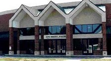
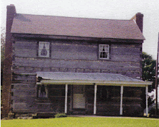
After passing the new three-lane wide portion of the interstate, the three lanes which start nowhere in particular and end a few miles further on, also nowhere in particular, I decided I'd be exitting at the Shelbyville/Taylorsville exit onto KY55, which having arrived there, I did, to the south. This road very quickly leaves the built-up sections of Shelbyville and for several miles is a cascade of large country estates and small rural homes, evenutally yielding to the village of Finchville. My youngest uncle and his wife were married at the Baptist Church is this little burg almost thirty years ago. Passing through town the road becomes a rural highway once again, but an interesting thing happens once you cross out of Shelby and into Spencer County (the newest addition to my 2009 travels). Suddenly much of the farmland has been given over to subdivisions. Northern Spencer County has grown by leaps and bounds during the last fifteen to twenty years, as is evident by this stretch of road. Before very long, KY55 comes to an intersection with KY155, and the 55 designation is directed to the south into the Spencer County seat of Taylorsville, a fairly sleepy little town, even on the busiest of days, and this wasn't the busiest of days. I drove into downtown Taylorsville, which is two blocks along Railroad Street, and four more along Main Street (shown in the picture looking east, not west as I was travelling). The town of Taylorsville and the name Main Street come to an end upon KY44's crossing over Brashear's Creek, where the name of the road changes to Mount Washington, the next town of importance along this route.
I will add here that the route KY44 traverses from here westward to Shepherdsville is known in history as the Wilderness Road, the old buffalo trail which begins in Kentucky (arguably) at the Cumberland Gap, proceeds to Crab Orchard, and from there to Harrodsburg, thence westward to this area and Shepherdsville, thence north to Okolona along Preston Highway, ultimately ending around where 26th Street would meet the Ohio River in the Portland neighborhood of Louisville, at which point the animals would ford acorss when the water levels at the Falls allowed. But, I digress.
Back in Spencer County, along KY44W, west of Taylorsville, at the top of the hill on the right is the Valley Cemetery, one of Taylorsville's older cemeteries, but also the one which during its recent growth has, invariably, grown as well. A dear friend of mine from many years ago, Gary Housley, is buried there. He was born the year after me and passed away in 1991. I always stop at his grave when in the area and did so today.
This stretch of highway, like KY55 on the northside of the county, is quickly becoming a string of subdivisions, dotting both sides of the road, and this pattern continues from this side of Mount Washington where you cross into Bullitt County, through that city, and from there over to Shepherdsville. I can remember when there were very few structures between these two towns, and the only excitement along the road was the old bridge across the Floyd's Fork of Salt River near Brasher's Station, named for the same person as was the creek back in Spencer County. That narrow steel bridge has been replaced by a very plain but also very wide standard-issue concrete deck, along with wide approaches from both directions, far more safe that the older decking, but not nearly as emotive.
Eventually the Bullitt County seat of Shepherdsville came upon me, at which point I entered onto the northbound ramp of I-65 and made my way northward making the ride home.
That's all for February.


1 comment:
Thanks for the interesting details on the route of the original "Wilderness Road". If, in the future, you visit any of the places along the "Road", and can get any more info, please weave it into a post.
Post a Comment