51. Some Answers - and a correction
Some answers to some trivia questions from previous posts.
Columbus, Kentucky is the city in Kentucky briefly considered as a possible new federal capital city, more centrally located in the expanding west. President Thomas Jefferson considered this move after a fire damaged the White House during the course of his term.
The city is located in Hickman County in the Purchase, where KY 80 empties into the Mississippi River and is home to the Columbus-Belmont State Park, which is where one can view in person the large anchor I pictured in the right column. That anchor, and the chain attached to it, played a role in the Confederate Army's execution of the Civil War. The opposing generals in the conflict which took place on November 7, 1861 were CSA Brigadier General Gideon Pillow and USA General Ulysses Grant. Grant went on to become the War's winning general, and later served, although not very well, as President of the United States.
I mentioned one day that Kentucky had a Lincoln County, but it wasn't named for the Commonwealth's only contribution to the list of people elected as President. Our Lincoln County was formed in 1780 (when Kentucky was still a part of the Commonwealth of Virginia) and named for a general from the American War of Independence (The Revolutionary War), Benjamin Lincoln, a native of the Commonwealth of Massachusetts. It was one of three counties created by the splitting up of Kentucky County, Virginia in the summer of 1780, the others being Jefferson and Fayette.
General Lincoln played a variety of roles throughout the War including at one point as a prisoner of the British. His last role was that of surrogate for his Commanding General George Washington, at Yorktown. When British General Lord Cornwallis refused to personally surrender his sword after the defeat, he sent a surrogate to do so. General Washington responded in kind, sending General Lincoln to accept.
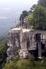
Jeptha Knob, or Jeptha's Knob, in eastern Shelby County, lies between US 60 and I-64 south of the village of Clay Village (sometimes written as one word, Clayvillage) and north of Hemp Ridge (also sometimes written as the one word Hempridge). The "knob" rises to a the height of 1188 feet above sea level. For comparison, the highest point here in Jefferson County is South Park Hill at 902 feet above sea level, located just southwest of the intersection of South Park Road and the Gene Snyder Freeway. The Freeway, west of I-65 over to the L&N overpass, runs along the foot of South Park Hill.
I used "knob" in quotation marks because the hill isn't a knob, as are the other hills surrounding Louisville as well as those speading across central Kentucky seem to be. It is now thought by geologists to be an asteroid which impacted the earth some 425 million or so years ago. It's nearest higher neighbor would be the Parksville Knob, a true knob, some 42 or so miles to the south-southeast, in the community of the same name in Boyle County, about one/third of a mile south of the intersection of KY 34 and KY 300. The Parksville Knob rises 1364 feet above sea level.
There is an old tradition about which very little has been written that George Washington, as a very young man, was sent to this area to survey lands on behalf of Thomas Fairfax, the sixth Lord Fairfax. The sixteen year old future president was a distant cousin of the British noble. It is documented that Washington surveyed lands well into what is now West Virginia. But the tradition is that a letter Washington wrote at the age of 22 mentions the high point "west of the river and east of the Falls of the Ohio" which he visited on one of the surveys. The unnamed river would be the Kentucky and the "Falls of the Ohio" became Louisville in the late 1770s. That high point would be Jeptha Knob.
In my post written for Saint Valentine's Day, but posted a day later, I included a picture of some Cuban ex-pats at a Mass celebrated at Saint Helen's Church in Shively. The purpose of that celebration was the installation of a statue of Jose Marti, a leading figure in Cuban history from the 19th century. The international airport in Havana is named in his honor. Marti was also a poet and one of his poems was set to music in the 1960s in the popular song Guantanamera. The Mass took place in September, 1963. The statue was erected in the Shively City Park behind City Hall. It was dedicated to those Jefferson Countians who fought in Cuba in the the Battle of Cardenas (the Filibusters) on May 19, 1850. Sometime in 2003 or 2004, the City of Shively tore down the monument and its present whereabouts are not clear.
As I had in the past pointed the statue out to Cuban refugeess who have made their American home here along the Left Bank of the Ohio River at Milepost 606, I've been curious for some time as to the purpose of removing the monument, but have not made any serious inquiries. Why would you tear down a monument dedicated to Jefferson Countians? I need to ask this question of either my friend Jim Jenkins, the former mayor of Shively, or his successor, Sherry Connor, whom I met during last fall's Shively festival when she and her mother visited the campaign booth of John Yarmuth, at the time a candidate for Congress. There is a little known movement led by Antonio de la Cova to restore the monument.
I wrote more than one entry of the idea of naming something in our community for Dr. Martin Luther King, Jr. The Louisville-Jefferson County Metro Council quickly wandered into this discussion, and finding the oil in the frying pan much too hot for their usual level of comfort and safety, just as quickly retreated, leaving the decision to the Commonwealth's legislature, currently in general assembly (hence the name) in Frankfort for one of the so-called "short sessions" approved by the voters through a referendum vote several years ago, one of many of the constitutional referenda offered to voters in my lifetime of voting, almost all of which I cast a "no" vote upon, including this one. This week the General Assembly approved naming Interstate 65 in Jefferson County the Dr. Martin Luther King, Jr. Expressway and directed the Transportation Cabinet to erect appropriate signage at intervals along the path. I-65 wasn't my first choice, but it will suffice. It is the successor route to the old L & N Railroad between the old North and the old South, and as such may be an appropriate road to carry the 20th century leader's name.
Finally, I made a mistake. I make a lot, truthfully. When I named this blog, I calculated my location along the Ohio River to be at Milepoint 606. Milepoint 606 is actually just a little further downriver from me. I am much closer to milepoint 604. Milepoint 606 is in reality almost directly in front of the bluff where George Rogers Clark's cabin sat in what would become the Town of Clarksville. It is nearly the exact point where Meriwether Lewis and William Clark (George's little brother) shoved off, for the first time together, as the Corps of Discovery in what has come to be known as the Lewis and Clark Expedition. I'm not going ot change the name of my blog - it will remain at Milepoint 606, and given that much of what has been written about in the blog has been of an historic nature, that point and that name are still, in spirit at least, correct.
![]() Labels:
History,
Land,
Louisville
Labels:
History,
Land,
Louisville


No comments:
Post a Comment