486. The Auburndale Loop is to be eliminated
Ok, I know many of you will have no idea what the title refers to. Were it not for family matters, I may not myself.
An article in today's Courier-Journal concerns changes in several TARC routes here along the Left Bank of the Ohio River near Milepost 606. One of those, along Route #6, which is commonly known as the 6th Street Route, is the elimination of a turnaround loop at Auburndale.
Where, you may ask, is that?
For some of the more senior readers of the blog, the former location of a school at the northwest corner of Palatka Road and Southside Drive (also known to some as Third Street Road at this point although that appellation doesn't actually begin until about a mile further south) marks what was once the Auburndale neighborhood. While tennis courts remain, the school is gone, replaced by a newer and larger one in the 1970s a few miles south. It is the neighborhood of Our Lady of Mount Carmel Catholic Church, the Ratterman Funeral Home, and at one time, Gordon's Corner, now home to a Speedway gas station.
Opposite Gordon's Corner, where the Rally's is now, is a very poorly paved circular drive from New Cut Road around to Third Street Road. It is where TARC busses, and before them Louisville Transit Authority busses, and before them trolley cars, would turn around and head back into town. And on the property of that turnaround sat a small white house which, for about one year, was the home of my grandparents the Hockensmith's and their teenage daughter Barbara, my mother.
They had left their Southern Parkway apartment and were building their new home off South Park Road between Okolona and Fairdale, the home in which my brother and I were raised where my mother still lives. But building that home took longer than anticipated and for a while, they rented the small white house on the Auburndale Loop which was owned by a Mrs. Probst (or maybe Probus). She lived at the top of the next hill on the other side of New Cut Road in a large farmhouse. Her farm is now the Cogan Properties' Park Place Apartment Complex, where the Burger King sits just across the railroad tracks. I can remember her big mailbox out on New Cut Road with the family name prominently printed.
Both Mrs. Probst's big white farmhouse and her rental cottage, the former home of my mother and grandparents are gone. And so too will soon be the Auburndale Loop.
*****
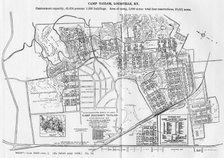
Below is a map of the Louisville Transit System dated May, 1954. You may not be able to see this, but at the very bottoom of the map, a little left of center, is the dot indicating the Auburndale Loop. Click on the map and it will open up to a much larger map in a new window. The old routes and street names are interesting and many of the routes have changed very little. Several of the other changes, which will take place on June 1, show up as part of the system on this map from fifty-five years ago.
![]() Labels:
History,
Louisville,
Travel
Labels:
History,
Louisville,
Travel


1 comment:
Hi,
We have just added your latest post "Ohio River, Left Bank, MP 606: 486. The Auburndale Loop is to be eliminated" to our Directory of Foreclosure. You can check the inclusion of the post here . We are delighted to invite you to submit all your future posts to the directory and get a huge base of visitors to your website.
Warm Regards
Foreclosu-re.info Team
http://www.foreclosu-re.info
Post a Comment