121. Along Preston Street Road, from Flat Lick Road to Norton Lane. Where is this?
Thirty-five years ago this week, I graduated from Prestonia Elementary School, at that point, a very old school in a very new building. Prestonia School has popped into my mind twice in the last few weeks. First there was the obituary in the Courier-Journal of John R. Masden, who was my principal from 3rd grade to 6th grade. It is reprinted here below.
MASDEN, JOHN R., 97, of Elizabethtown formerly of Bullitt County, KY died Monday, June 4, 2007 at Helmwood Health Care Center, Elizabethtown, KY. He was a native of Bullitt County, KY. An Army veteran of World War II, a retired teacher for the Jefferson County School System and a former Principal for the Prestonia Elementary School and also a member of the Davidson United Methodist Church in Shepherdsville, KY. He was preceded in death by his wife the former Ruth Weller. He is survived by his cousin, Joyce Sturgill of Lebanon Junction, KY who cared for him; two nieces, Sandy Cove of Dayton; OH and Ann Southerland of Maple City, MI; and a nephew, Tom Hackney of Sutton Bay, MI; and a loving friend, Renata Reever of Las Vegas, NV. Funeral: 11 a.m. Saturday, June 9, 2007 at Kappel Funeral Home, Lebanon Junction, KY with Rev. John Vaught officiating. Burial will be in Hebron Cemetery, Shepherdsville, KY. Visitation: 1-8 p.m. Friday and 9 a.m. Saturday at Kappel Funeral Home, Lebanon Junction. Expressions of sympathy to his church.
Published in The Courier-Journal on 6/7/2007.
That was last week's news. Then yesterday was another article in the Courier which, well frankly, didn't mention Prestonia, and that prompted the following essay concerning the Norfolk/Southern Railway trestle which divides the present Camp Taylor neighborhood from the present Belmar neighborhood, both of which are parts of the former neighborhood known as Prestonia, the area for which my elementary school was named.
The article on the Camp Taylor / Belmar trestle (link below) caught my eye and causes me concern over place names. As many of you know, names of streets, places, and neighborhoods have long been an interest of mine and the city does an poor job of properly identifying everything. Having formerly been a resident of Camp Taylor for nineteen years, I remain keenly interested in the area. But, before being a Camp Taylor resident, I was a student at Durrett High School, and before that Prestonia Elementary, from which I graduated in 1972. In fact, before there was a Camp Taylor and before there was a Belmar, there was Prestonia.
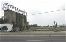
The area along Preston south of what is now called Locust Lane (the former Flat Lick Road) and as far south as what is now called Gilmore Lane, (the former Norton Lane) gradually became what today we would call a town center. A siding along the Norfolk Railroad, then the Southern Railroad, was established and is still there, as shown in the first picture to the right. This stop was known as Prestonia as early as 1907. It probably served people exiting to the new residential development known as Audubon Park, first laid out by a Mr. Harmon in the 1890s on land formerly owned by Mrs. Sallie Durrett. There is a listing of the neighborhood with that date in the 1907 Report of the Interstate Commerce Commission, on page 312 of that document listed as item 237, dated December 23, 1907.
Prestonia School, my Alma Mater, was a landmark along Preston Highway for many years, dating from 1912. The school was located at three different locations, the first one up near Locust Lane and previously called Spring Garden School. Sallie Phillips Durrett was a teacher at this school. The second and most prominent stood on Preston, opposite what is now called Belmar Drive. That school closed in 1970 and a new school building was opened on the Durrett High School campus one mile south. Prestonia School finally closed its doors in 1981. The most recent school building is now known as the Gheens Academy. Another school, called Prestonia #2 existed in the 1930s along Crittenden Drive where the C. B. Young Jr Educational Center is near Central Avenue.
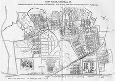
The beginning of the end of Prestonia came with the establishment of Camp Zachary Taylor in 1917, established on grounds for the most part owned by the Durrett and Phillips families, which had owned property in the area since the early 1800s. Jenkins Phillips first land patent in the area dates from 1790. The "Main Camp" covered most of the area between Preston Highway on the west and Beargrass Creek, near to Newburg Road on the east, and from Clarks Lane on the north to the northern line of Evergreen Cemetery on the south. Excluded from the camp was the French farm (generally the area along Delor, Colin, and Pindell avenues); as well as that part of Audubon Park which was already under development, and the original Prestonia neighborhood which ran along streets of the east side of Preston, now known as Morgan, Farmdale, and Sprindale avenues. Extensions of the camp were located across the street, where Value City is now, extending over to Crittenden Drive and out to Ash Bottom Road, where the FedEx building is now on the southwest side of the airport. A second extension existed a little north of this one near where the Denny's is at Crittenden Drive and Eastern Parkway and extending out to the Churchill Park School. Another extension was out along what is now Minor's Lane near South Park Road and the Snyder Freeway, an area which today looks much as it did then, now deprived of homes levelled in the ever-growing Airport Expansion Project, first begun in the 1980s. A final extension was in the hills of southwestern Jefferson, western Bullitt, and northwestern Hardin counties, a firing range which eventually was renamed Camp Knox, and years later enlarged and renamed Fort Knox, after the closing of Camp Zachary Taylor.
But, I digress.
Prestonia as a community existed for most of the early to mid 1900s. The school opened in 1912. By 1921, there was a Prestonia Bank, owned by George Schuster. Also that year, the Prestonia Post Office was established. The Prestonia Presbyterian Church was established in 1924, changing its name to the Fourth Presbyterian Church in 1938. The was a Coal storage factory owned by the Oehrle family. A Prestonia Garage, originally a stable, existed on the west side of Preston where the old Burnett Brothers Auto Shop later located.
After the closing and subsequent selling of the lands once belonging to Camp Taylor, two new communities arose. Camp Taylor, not Camp Zachary Taylor, formed inside the area between Audubon Park, Durrett Lane, the railroad, and Illinois Avenue. This, of course, was the area I lived in, first in two different apartments along Belmar Drive, and finally, for seventeen years at 4104 Lee Avenue. Another picture on the column is from the old Camp, taken in what is approximately my backyard, looking southeast toward where Camp Taylor Memorial Park currently is situated. Another neighborhood, Belmar, was established as a subdivision around 1928, developing that part of the camp between the railroad, Preston, and north of Morgan Avenue. That subdivision, Belmar, eventually overtook the older name of Prestonia as an identity for the area. Even homes in the original Prestonia neighborhood along Farmdale and Springdale have been absorbed by the neighborhood's name.
Much later, the western side of the Prestonia neighborhood was developed by Weyer and Mann developers, who built the subdivision which used to be along the south side of Phillips Lane. Streets in it were known as Fontaine, Weyer, Nally, and others. In the 1970s, when the federal government began distributing "block grants" funds for cities, they required areas to be laid off into neighborhoods. Some areas fit a well-defined description and the neighborhood name fit. Others, such as "Poplar Level," the area north of the Watterson on the east side of Poplar Level never went by that name, but nonetheless that is what is it officially called. Some areas did not fit any description and were called "Remainder of City." It was at this time that the Prestonia name was revived, identifying an area which would, for the most part be consumed by the airport expansion. The part of it which wasn't was later called East Prestonia and finally Belmar, after the subdivision name from those earlier years.
As a note here, the street now called Belmar was originally known as Kentucky Avenue from Preston to Lee Avenue and Indiana Avenue from Redwood Avenue to Poplar Level Road. East of Poplar Level Road, the former Indiana Avenue is now known as Trevilian Way. In 1956, the old Camp Taylor Post Office was annexed into the Louisville Post Office system. To avoid confusion, the Kentucky Avenue name was changed to Belmar up to what is now Redwood Avenue. Redwood was also Kentucky Avenue out to Poplar Level Road. This was to avoid confusion with the much longer Kentucky Street in the Louisville Post Office area. The Belmar name was also adopted for that part of Indiana Avenue, north from the intersection with what is now Redwood, since it no longer directly connected with the other part of Indiana to the west. The post office also changed the name of a short alley near U of L from Indiana Avenue to Riley Avenue, again because it was the shorter of the two streets with the same name. I've never known where the Belmar name, originally applied to the new subdivision in the 1920s came from. I do know the 1895 winner of the Preakness was the horse Belmar.)
The whole point of this discussion is my concern over the loss of an historical name, Prestonia. I would propose that should a name sign be erected on the trestle identifying the area, as the C-J article suggests, the name Prestonia be included in identifying the area west of the Railroad overpass, as such name is older than either Camp Taylor or Belmar, both of which were formed out of land in the original Prestonia area.
http://www.courier-journal.com/apps/pbcs.dll/article?AID=/20070613/ZONE06/706130436/-1/ZONE06
![]() Labels:
History,
Louisville
Labels:
History,
Louisville


2 comments:
Hi Jeff! MaDonna here. I love wandering down memory lane with you and seeing the areas as they were when we were kids. You know way more history than I but we sure seem to have the same thoughts of so many of these areas. Weren't the "row" housing in Camp Taylor barricks that were remodeled into apartments? An when I was in the 7th grade at Durrett High I met a girl who lived in one of those with 3 other siblings and her parents! I guess being and only child for my first ten years made me very territorial of my space ... but whoa! 6 people in one of those places seemed impossible. Well, got to go but keep walking me through the memories.
Madonna,
Let me add a little more information to what Jeff has written, and to answer your question, there are no barracks remaining from the original Camp. There are a few of the Latrines that are still standing, and are now small houses. Very few of the buildings were not torn down after the camp was closed. The contract that the army signed with the city stipulated that all the buildings were to be removed by the army when the lease was surrendered. Fortunately, some the buildings were bought along with the land, and the new civilian owners remodeled them into dwellings. You can read more about Camp Zachary Taylor at http://camptaylorhistorical.org/
Post a Comment