Hidden Location #9
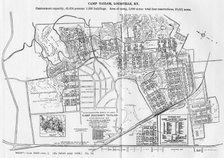
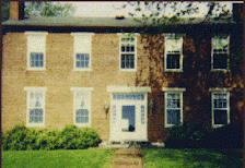
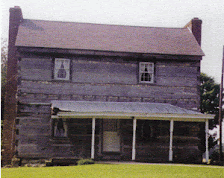
Once again Marty Meyer correctly identified our hidden location, which was Cardinal Drive alongside Audubon Golf Course. This picture is taken in the 1400 block of Cardinal, a streetname which runs along the north and south sides of the Audubon Golf course but the two sides never meet. There is a right-of-way surrounding the golf course which on the map is identified as Cardinal. But the southern-most Cardinal, where our recent picture was taken, dead-ends a few block to the east. On the northside, Cardinal turns into Nightingale Drive at Eagle Pass. Technically, this isn't true as the Cardinal right-of-way proceeds around the property line between the Fincastle Heights apartments (actually a mutual ownership cooperative) and the new condos which face the golf course. You may also notice that a few of the houses on the southernmost Cardinal look more like those in Audubon Park than those in Camp Taylor. There is a reason. Before Camp Taylor the neighborhood was Camp Zachary Taylor the military installation, it was farmland largely owned by Sallie Durrett and her heirs. Some of it had been sold off into parcels. The entirety of what is now commonly known as the Camp Taylor neighborhood was in fact laid out as part of the Audubon Park subdivision with similarly rolling lanes and circles and small parks. But the Great War interfered and most of it was bought by Uncle Sam. The 1400 and 1500 blocks of Cardinal were already begun with homes similar to those across the fairway in what is now the City of Audubon Park. But they are all that were ever built on the southside. Eventually Camp Zachary Taylor closed, with most of its operations moved to the newer Camp Henry Knox, now Fort Knox. The subdivision which became the Camp Taylor neighborhood abandoned the plans of Audubon Park and used as its streets those created by the United States Army. A few new ones have been added - McKay, Grove and Orchard (where the Army maintained a fruit orchard), and some others, but for the most part the streets in use today in Camp Taylor are those created for service in World War I.
Below is a new hidden location. Good luck.
![]() Labels:
Hidden Location
Labels:
Hidden Location


7 comments:
Thanks for the interesting notes on the architectural of Aububon Park vis-a-vis Camp Taylor (nee Camp Zachary Taylor). I've always noticed the differences and wondered why.
Jeff,
Alright, after careful consideration and much consternation I have discovered that the photo is somewhere outside of the "circle of love" but inside the City of Louisville.
Marty
he has one of those programs that takes a picture and then compares it to the mapquest/google/lojic database which is cheating i think. i think noble should give him one that isn't in the google database. ive only known one of these, the one in old louisville by ormsby.
Anonymous said...
he has one of those programs that takes a picture and then compares it to the mapquest/google/lojic database which is cheating i think. i think noble should give him one that isn't in the google database. ive only known one of these, the one in old louisville by ormsby.
Wrong, I am just well travled in louisville, the last one was easy after I turned on the computers magnifying device and saw there is a golfer and hole flag. That then narrowed it down to the courses in Louisville. Know ing that Jeff lived in and owns property in the Camp Taylor area made me look at Audubon golf course boarder streets on google until i saw the fire hydrant to compare. The current one can be found by looking at streets in the southend, theres just a whole lot more of them. By guess is its by his mothers or grandmothers house.
Marty
it looks vaguely like Minor Lane Heights but I haven't been out that way in a while and I'm not sure what all's left out there these days (airport buy-outs)
it isn't minor lane heights. the picture has brick homes. i dont think minor lane heights had any brick homes. any besides, unless the picture is several years old, there aren't any homes left in minor lane heights.
so we have brick homes, sidewalks and street lights, so it is in the urban services district in all likelihood. thats more like hikes point than the southend. where does noble's mother and grandmother live?
Knowing that Jeff lived in and owns property in the Camp Taylor area made me look at Audubon golf course boarder streets on google until i saw the fire hydrant to compare. i don't think minor lane heights had any brick homes. any besides, unless the picture is several years old, there aren't any homes left in minor lane heights.
Post a Comment