676. 676 and #12
First, the answer to Hidden Location #12 was offered to our seven faithful readers by someone known on the wires as JeffnClifton. I have somewhere in the corner cobwebs of my mind that his real name is Jeff Nowlin. Is that correct? The picture was taken in the 200 block of Idlewylde Drive looking south toward Calvin Avenue.
Appropriately the answer came from a self-identified Cliftonian as this street is somewhere along the borderlands between Clifton, Crescent Hill, and Clifton Heights. To his credit, Curtis Morrison had taken a stab at the location and was headed in the right direction when he mentioned Lower Brownsboro Road. But, as there were no Iron Facades or Downtown Bridges involved, and the fact that it is very likely most of the residents in this area were Greg Fischer supporters, he somehow lost his way.
I wish I knew more of the background of this area, as it is my custom to try to give a short historical sketch once the hidden location is revealed. I'll have to return to this one on another day as I know very little specific information.
*****
The other part of this entry returns us to an old custom - that of using the entry number as a lesson for a Kentucky highway of the same number. Today is entry #676 so we'll speak briefly about KY676, a major cross-county four-lane in southern Franklin County. KY676, I believe, was built in the mid to late 1970s. The purpose of the road was to alleviate traffic on downtown Frankfort's city streets.
Frankfort stands by hills surrounded - replacing Frankfort for Zion, so would go an altered hymn by the Irish Poet Thomas Kelly, written in 1806. Anyone who has ever driven into Frankfort knows one must go downhill to get down to the city proper. The city was originally laid out in the "S" curves of the Kentucky River, where the division in 1780 of Kentucky County, Virginia occurred, at the mouth of Benson Creek into the Kentucky River. There is presently a Riverfront Park overlooking some of this, along Wilkinson Street north of Broadway.
From the south, one enters Frankfort along either the old Lawrenceburg Pike (KY420) or more often, along US60, down Louisville Hill into Second Street, which is also the major approach from the west, the minor one being the Devils Hollow Road (eventually KY1005), which was the original entry from Louisville. From the north are the Bald Knob Pike (US421) and the Owenton Road (US127). From the east, one comes down East Main Street either from the Georgetown Pike (US460) or from Versailles Road (US60). All of these approaches at some point go down hill, and often steeply. Anyone coming into town prior to the construction of KY676 did it on one of these roads.
With the expansion of what was once called the Health Department and what many people still call the Human Resources Building on East Main Street, a need arose to create a "back" way into the project. This also allowed for expansion at Kentucky State University (KSU), opposite the Human Resources Building. KY676, which is signed as the East-West Connector allowed for this back entry. BEginning on the west side at US127 the road went down hill with its first original intersection at an extended Collins Lane, which at one time had jutted west toward US127.
Further down the hill came the intersection with KY420 which hugged the stone wall along its west side leading down into South Frankfort below the Capitol and Executive Mansion. This area has always been prone to flooding. At the bottom of the hill, the road crosses the Kentucky River in the Big Eddy area, on the Julian M. Carroll Bridge, named for the previous governor from McCracken County who after his term as governor remained in Frankfort and is now serving as a State Senator for Franklin, Anderson, Woodford, and parts of Scott and Fayette counties.
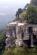
The eastern side of KY676 then works its way back up the hill with Frankfort's Capital View Park off to the north along the old Glenns Creek Road, redubbed as Kentucky coffeetree Drive, for what was for a few years Kentucky's official tree, and a variety of venues off to the south including Kentucky's Vietnam Veterans Memorial, shown below. The memorial, dedicated in 1988, takes the form of a granite sundial with the dial, or gnomon, of stainless steel. The names of Kentucky's 1100 fallen and missing veterans from that war are strategically placed such that the tip of the shadow produced on a given day by the gnomon falls upon the date that the veteran was lost to the war. It is an eerie and sensitively designed memorial which everyone should visit.
The newer Franklin County Regional Correctional Facility is also up on the ridge to the south of the highway. The major intersection on this side of town is with Martin Luther King Jr. Drive (KY1659), a major four-lane city street connecting with the back (and effectively the main) entrance of the Human Resources Building, as well as all of the KSU's facilities off to the east. Martin Luther King Jr. Drive, the former Maryland Avenue, then crosses East Main Street and directly accesses the main campus of KSU. South of the East-West Connector, this street is known as Glenns Creek Road.
KY676 progresses further east, generally following the old railroad path which eventually leads to Midway and Lexington and has recently become a topic of discussion for a light rail line connecting Frankfort with Kentucky's largest two cities, Louisville and Lexington. But, I digress.
After crossing Galbraith Drive, the road makes its approach to Versailles Road, East Frankfort's major thoroughfare. The intersection here was one of a few "prototypes" combining some elements of an interstate intersection with cross-over stoplighted street level intersection as well. The Bardstown Road/Watterson Expressway intersection in Louisville is another example of this type of intersection. KY676 ceases numerically at this point, but the roadway itself extends under US60 becoming the Leestown Pike on the east side and numbered as KY 421, eventually leading into Lexington under the name West Main Street.
For most people who use it, it is simply the easy way into and out of the Human Resources Building on the east side of the river, and the circulating Captial Parking garage for the west side. Now you know.
KY676 photo by H. B. Elkins
Kentucky Vietnam Veterans Memorial photo by Lon Whitson
![]() Labels:
Frankfort,
Hidden Location,
History,
Land,
Travel
Labels:
Frankfort,
Hidden Location,
History,
Land,
Travel


1 comment:
That is correct.
Post a Comment