674. "Come on out to William H. King's . . . . , and Hidden Location #10 revealed
Out at the Fairgrounds, except we officially don't call it that anymore, there is a show going on, a show most of us in Louisville have attended at one time or another in our lives. It is being advertised as the Louisville Boat, RV, and Sport Show, and there is a little jingle that was being played earlier on 103.5 FM - WAKY - or as we would say here along the Left Bank of the Ohio River near Milepost 606, Wa-Kee Ray-Dee-Oh! The trouble is I can't tell you how the jingle goes because it hasn't been around long enough. In fact, as soon as I heard it I started singing another jingle for the same event. If you are old enough, you know the real jingle for this show goes "Come on out to William H. King's Sport, Boat, and Vacation show, 'Cause it wont be long until it that time of year" Now I know that more than a few of you were singing along by the time you got to the end of that line.
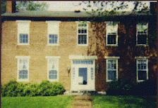
If you are old enough to remember the William H. King jingle, you're probably old enough to have recognized the location in our most recent Hidden Location entry. Marty Meyer correctly identified it as the corner of S. Second Street at W. Florence Avenue. Indeed, that is exactly where it is. The picture is looking north along Second Street's southbound lanes. Back in the day, as people like to say nowadays when they are talking about something that happened a long time ago - I'm especially unnerved when I hear one of my 23 year old friends referring to back in the day and you find out they mean sometime around 2007. But, I've digressed.
At one time, this corner was an integral part of the Watterson Expressway's intersection with KY1020. The former exit sign read "2nd St - 3rd St - Southern Parkway" heading in either direction on the Watterson. If you were in the westbound lanes and you took this triply-defined exit, you made a 90 degree turn off the Watterson and up the little hill on 2nd Street to Florence. At that point you were directed 90 degrees to the left (westwardly) along Florence over to 3rd and even further, if you wanted, over to Southern Parkway. That hill was known to oldtimers as Bluebird Hill although I do not know exactly why.
Marty identified the intersection as part of Wilder Park and this is qualifiably correct, but qualifiably incorrect as well. While the old City of Louisville neighborhood boundary for Wilder Park extended this far south, the original development, which began in the very late 1880s extended no further south than Fairmont Avenue. It is possible that Fairmont is named for the little hill to the south that came to be known at some point as Bluebird Hill, while the valley between Fairmount and the eventual Florence was known as Bluebird Valley.
The original Wilder Park subdivision, built on land once occupied by the old Greenland Race Track, an early Churchill Downs comptetior, ran from Collins Court south to Fairmount, and from Third Street east over to the old L&N Railroad. It was developed by a real estate investor by the name of Angus Allmond - hence Allmond Avenue which eventually graced (loosely used) the far eastern edge of the far southern edge of the neighborhood. The property was owned by a woman named Wilder Collins. Most of the Wilder Park homes north of Fairmont, in Mrs. Collins original plat, were built in the period between 1890 and 1930. Homes south of there came along just before and just after World War Two.
2nd Street, the divided avenue in the center of the development, was originaly known as Wilder Boulevard. The east-west cross streets followed the pattern of those streets north of Churchill Downs, adopting letters as their street names. Wilder Park's letters ranged from P to V. The only Louisville streetname remaining from the configuration is M street, just north of Churchill Downs.
(Unrelated to this story is that of the City of Oakdale, which began up near The Granville Inn at what was then called A Street, and extended south to about where the Watterson Expressway is now, between the L&N on the east and Rodman Avenue on the west. An Oakdale neighborhood remains south of Churchill Downs.)
So, congratulations once again to Marty Meyer, now 7-1-1-1 in our little game. I'll find a new location tomorrow or Sunday.
![]() Labels:
Hidden Location,
History,
Land
Labels:
Hidden Location,
History,
Land


1 comment:
Nice to see that someone else remembers the jingle.
Post a Comment