HL 14 identifed; HL 15 below
Ok, y'all are getting them too quickly. I am going to have to take more obscure pictures -starting with the one after Hidden Location #15 below. HL15 should be very easy, but I promise more difficult ones in the future.
But first some comments on Hidden Location #14. John Flood correctly identified the location, writing "This looks like corner of Penile Rd, W. Manslick Rd & Old New Cut Rd. in Fairdale." Yes, to a point - an italicised point. The street names are correct and I'll address two of them below. And, yes, I would certainly call that intersection part of Fairdale. But, according to the United States Postal Service, I was in "Valley Station" when I took the picture while standing along the southern side of W. Manslick Road. All of the Penile Road addresses going off to the right also carry the Valley Station zip code of 40272. But the territory to the left on Old New Cut Road and on the other side of the intersection is, indeed, Fairdale, whose zip code is 40118.
I have nothing to report about Penile Road, and that is probably a good thing. So, let's start with Old New Cut, an interesting name. About twenty-five years ago, coinciding with the opening of the Gene Snyder Freeway, a road was built connecting New Cut Road as it then existed with W. Manslick Road, about 3/4 mile closer to Fairdale. This 3/4 mile stretch of highway went unnamed for many years. People referred to it as New New Cut or New Manslick or "that new road connecting to the Snyder." Eventually, however, developers bought the land along the northern side of the road, erecting several warehouses and a motel. With such development came the need for addresses, and address numbers need road names to make any sense.
After some - not much - discussion, it was decided to call the new stretch of road "New Cut" continuing the name of the road which extends south from Iroquois Park to this point. Further it was decided to call the older stretch of New Cut, the one now cut-off and appearing in our picture, Old New Cut, an awkward name to be sure. But the reason had more to do with the other street involved in the new connecting road - W. Manslick. Were the county streetname deciders going to give us yet another Manslick to deal with?
Check any map of southern Jefferson County and you will find six close but unconnected streets - eight if you count "Old Manslick" sections - with the name Manslick. At one time there were a few more, like the Echo Trail sections of southeastern Jefferson County. Presently the easternmost Manslick Road runs from Beulah Church Road west to Pennsylvania Run Road. A second section, starting about two blocks south of the first one, runs from Pennsylvania Run Road west to what is officially called Shepherdsville Road, but which many still call Old Shepherdsville Road, usually shortenend to Old Shep. A third Manslick starts about a block north of this one and runs from Old Shep west to Preston Highway, which, if you are wondering, was at one time the companion New Shepherdsville Road, but that name never caught on. That's all of the southeastern Manslicks.
Coming in from the southwest, beginning at the intersection of Berry Boulevard and Seventh Street Road, is the first of three Manslicks on this side of town. This one extends south to Palatka Road. A second Manslick picks up about 3/4 mile east of this point and runs south to Saint Anthony's Church Road. Another 3/4 mile from there, a third Manslick begins at Third Street Road and extends toward Fairdale, to the point in our Hidden Location #14 picture, at Old New Cut Road.
Why all the Manslicks?
First, let us dissect the name into its original name which was Mann's Lick, the name of a salt lick owned presumably by the Mann family. Actually, that's exactly what it is. Mann's Lick was a salt lick operating in the area of present day Glengarry, or Glen Garry, a subdivision in Fairdale near the intersection of National Turnpike and the Gene Snyder Freeway. Salt licks dotted southern Jefferson and much of Bullitt counties before places like Louisville and Shepherdsville existed. Thus, we are speaking of pre-Revolutionary War times. A community existed in this area known as Newtown. Newtown, in fact, grew large enough to be incorporated as a city in 1794, but its existence was one of about thirty-five years in the late 18th and early 19th centuries.
The roads leading in from the east and west to Newtown were known as the "roads to Mann's Lick." One group came south from the Falls of the Ohio River, along the north-south buffalo trail generally today followed by the CSX (formerly L&N RR), I-65, and Preston Highway. They are generally known simply as Manslick Road. Another came from the east, perhaps a more southern path of the Midland Trail, or a more northern path of the Wilderness Trail. I really don't know. These, today, are generally known as E. Manslick Road. The roads closest to Fairdale are called W. Manslick Road. Now you know.
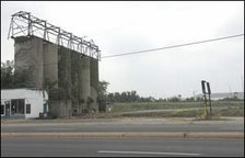
So, here is a new picture. Again, it should be very easy to identify.









1 comment:
Palatka and Manslick looking towards St.Andrews.
Tim Meyer
Post a Comment